Grange Villa and the Alma Pit
Before the Mine
Before the Alma Pit, showing the Twizell before its course was straightened and features added.


Grange Villa in 1915
Now massively more developed. The Twizell has a much straighter course now.
Grange Villa
As with other colliery villages, there was very little of Grange Villa before the Alma Pit was opened in 1858.
Owned by James Joicey, the Alma Pit was named after the Battle of the Alma, which was fought during the Crimean War and took place on 20 September 1854. In 1872, a brickworks was opened, between the colliery and the Twizell.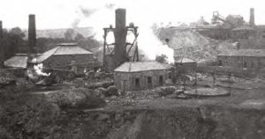
It may have been then that the Twizell was diverted to make room on the bank. Certainly, once the brickworks appear on the map in 1895, the burn follows a straighter course around the new buildings.
The bricks from Alma Brickworks were stamped ‘Joicey West Pelton’ and were used to build local houses, including much of Craghead Front Street. Both the Alma Pit and the brickworks closed in 1921 and the population of Grange Villa declined as families moved elsewhere looking for work.
The pit reopened during the Second World War and remained operational until it closed for good in 1958 and the miners transferred to Handenhold Colliery.
In 1951, Grange Villa was placed in Category D under the Durham County Development Plan, meaning that no new development would be supported in the village.
Many other nearby villages were also labelled Category D, including: Craghead; The Middles; West Pelton; Newfield; Waldridge. This was relaxed in the 1960s, but the village suffered a further blow with the closure of Handenhold Colliery in 1968.
Greening the Twizell
The 1970s and 1980s were a time of reclamation and regeneration as the scars of the area’s industrial past were cleared away and work was done to make it greener and more pleasant.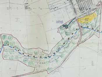
When the Alma Pit closed, the Twizell Burn had been diverted through a large culvert, which subsequently became dangerous. The valley itself was full of burnt shale workings and other waste, creating a dangerous and unsightly area in what had once been a wooded valley.
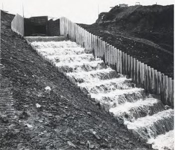
The Twizell was diverted back towards its original course by use of a man-made series of waterfalls, with a total drop of twenty metres. A concrete culvert, nearly two metres in diameter, was used to cross the C5 road (Newbridge Banks).
The old railway bridge and pithead buildings were demolished. The shafts were capped and the area landscaped, with the addition of footpaths to allow public access to what would become a pleasant wooded area.
In March 1979, following an unprecedented combination of heavy rain and snowmelt, the culvert under the C5 road collapsed and about thirty metres of the road was washed out.
A new watercourse was constructed from a point over a hundred metres upstream of the culvert, with measures such as concrete steps and stilling basins, to protect against such extreme flooding in future.
